
Charleston is one of several cases that has been predominantly solved over the years, while investigators consistently fail to publicly assemble a cohesive and comprehensive answer. There is no need in this case to reinvent the wheel. The Expedition Unknown production was mere yards away from a casque location logical both from an interpretive standpoint as well as a logistical one given the unforgiving subterranean condition of Charleston water-front soil densely packed and littered with centuries of debris.
Many details appearing in this solution proposal were previously identified by countless investigators, including the folks at PB Works. PB Works has proven to be an excellent resource for this case in particular.
The Charleston solution embodies the effectiveness of a systematic approach when interpreting the puzzles. Deductive reasoning has proven to be one of the most effective investigative tools for solving Secret cases. Let’s apply this strategy to the first several lines of the verse. To further explore a comprehensive and consistent set of frameworks prioritizing objective discernments for determining true Secret solutions, click here.
Of all the romance retold
Men of tales and tunes
Cruel and bold
Because these lines mimic portions of the Treasure Island preface, some assume a contextual reference to Treasure Island and Charleston is the only intent of this passage applied toward determining the Charleston solution. This seems incredibly odd given that we rely on the verses to establish our starting position. However, thanks to the Japanese translation, we know that “romance” evokes some connection to “medieval Europe”. Since we already strongly suspect WPG and the integration of the CSA Submarine Memorial Fountain, a northern point of origin along Meeting St. is a logical proposition. So let’s start there.
Between Cumberland and Queen on Meeting St. we find the Circular Congregation Church built in the “Romanesque” style. To “retell” or repeat something is often characterized as a “circular” activity, such as circular reasoning where your final point leads into your beginning point. Taking lines two and three at face value, where do people go to hear songs and stories about both righteous and unrighteous individuals? They go to church. This interpretation fits all qualifiers established by the puzzle.
Immediately to the east of the CCC we find Church Street, the distinct contour of which is emulated within the lion’s mane in image 2 and further confirmed by the appearance of a cross. The church found within the street’s unusual, momentary curvature is St. Philips. So now we have a second church compliant with the first three lines.

Seen here
By eyes of old
These lines are quite genius and have thrown many investigators for a loop. The original St. Philips Church was built in 1680 on the corner of Broad and Meeting St. and was replaced in 1723 by the new Church St. location. This means that the original church which started the “oldest” European American congregation in South Carolina was only seen by “eyes of old”. “Seen here” is a reference to the location of the original church building at the intersection of Broad St. and Meeting St., having us travel of few blocks to the south. This same intersection is verified by the painting in a variety of ways.
The tree branch depicted in the painting represents a section of Lockwood Dr. starting near the Ashley River, matching the contours in the painting as illustrated below, later transitioning into Broad St. Many have associated the tree branch with Coleman Blvd. and the corresponding Silas Pearman Bridge. While the contours are very similar, and this very well could be purposeful misdirection by Byron, there are a few issues. The inclusion of the Pearman Bridge seemingly serves little purpose to the actual solution. Furthermore, what is a pear doing on a branch with evergreen needles when pear trees have “broad” leaves? This suggests that the representation is alternatively meant to be Lockwood Dr. which turns into “Broad” St. The branch also resembles the letter “L” with a curved vertical member, providing a potential, additional allusion to Lockwood Dr.
Update 3/14/26: It has been brought to my attention that the above mentioned roads were configured in a slightly different format in 1982, and the Robert B. Scarborough Bridge did not exist at all. The visual match is therefore not quite as compelling, but there is still a diminished level of viability to the inclusion.

The branch in the painting appears to line up directly with the woman’s arms as it goes behind her body. She is holding her arms in a very peculiar position with her elbows broadened and her hands clasped or “meeting”. This represents the intersection of Broad and Meeting St. This reinforces our previous interpretation of “eyes of old” representing the historic location of St. Phillips at Broad and Meeting for this Charleston solution.
This intersection is commonly referred to as “the four corners of law” representing four “wings” or “branches” of law: federal, state, local, and ecclesiastical. It just so happens that the woman representing this intersection has four wings. The wings, resembling that of a butterfly or moth, also have “eyes” on them, which could further correspond to the lines “seen here by eyes of old”.
We can glean additional location confirmations from characteristics included in the wings. The top wings include a pattern that emulates stone street pavers on Chalmers St., found above Broad and Meeting from a map perspective map and includes the “Old Slave Mart”, reflecting the African immigration focus of the puzzle.
From Broad and Meeting, we need the painting to get us to White Point Gardens. The tree branch we identified as Broad St has a string with an ornament or mask hanging from it. This object is meant to look like Fort Sumter, but in reality it is White Point Gardens (more on that in a moment). Just as there is a considerable distance between our two locations on the map, this distance is seemingly emulated in the painting.

What look like hands of a clock on the mask have “white points” on the ends, and the number two is created by excess string where it is tied to the mask as illustrated above. When comparing this imagery from the painting to the map we find accurate geographic mirroring. The upper most “white point” corresponds to the entrance to WPG, while the number 2 corresponds to the location of 2 Meeting Street Inn. While it is not a perfect match, there is an interesting correlation between the arms of the clock and the angle of S. Battery where it intersects with Meeting St.


Stand and listen to the birds
Hear the cool, clear song of water
Traveling to the Two Meeting Street Inn as indicated in the image, we arrive at the southern termination point for Meeting St. intersecting with the northern edge of White Point Garden along South Battery. At the entrance to WPG, we immediately encounter the CSA Submarine Memorial which features an active fountain, allowing us to literally hear the trickle of water.
Update 12/31/25: Taking the first letter of the words “cool, clear song” forms the abbreviation CCS, which may represent the Confederacy of Charleston South Carolina, in conjunction with the memorial.
Steps behind the memorial is the park band “stand”, where we can presumably “hear” the water trickling as the verse infers. According to online sources, White Point Gardens is seasonally home to different varieties of Herons. Ironically, a bandstand is intended for public musical performances to be “heard” from, while the verse suggests we hear things from the bandstand. Positioning ourselves at the bandstand offers a straight shot to our next verse mandated location for this Charleston solution.
Harken to the words:
Freedom at the birth of the century
Or May 1913
As often cited by other investigators, these lines reference the USS Maine Capstan previously located where the William Moultrie monument is now. This monument was directly to the east on the same path as the bandstand. A plaque on the east side of the monument details the sinking of the USS Maine. The sinking occurred in 1898, or just before the turn of the century. The attack led directly to the Spanish-American war, initiated by Cuba’s desire for independence from colonial Spanish rule and “signaling” the USA’s international dominance. Both subsequent events can be characterized as resulting in different levels of “freedom”.
The monument was presented to Charleston in May of 1913, corresponding to the verse, as identified by a plaque on the north side of the monument. The positioning of the two plaques seems to be affording us a choice whether to continue following an east route (which won’t take us very far) or a north route. It just so happens that the next point of interest identified by the verse is north/north-west of this location.
A modified likeness of the capstan appears in the contours of the lion’s mouth.

One potential point of contention generated from this Charleston solution is the impression created by the Japanese translation clues, directing us to search a catalog of historical dates for our May 1913 connection. However, the dedication date of a memorial in Charleston is unlikely to be included in such a publication. The question becomes this: did Byron specifically instruct such action, or is this the assumption of the JT author? We already know that the JT clues incorporate subjective speculation and commentary from the author directly and not Byron himself. In this regard, we should prioritize communication directly from Byron through his puzzle. For a more in depth analysis of the extra Japanese translation clues, their implications, and their perceived accuracy, click here.
Edwin and Edwina named after him
Or on the eighth a scene
Edward Blyden visited Charleston as a response to the African American presence there, detailed in the book Abroad in America. Two of his children were named Edwin and Edwina. I can find no direct relationship between Blyden and WPG, which is unsatisfying to say the least. However, the word “or” seems to give us a pass to instead apply this clue for the contextual purpose of assigning Charleston to verse 6 only.
“Or on the eighth a scene” pertains to a historical marker commemorating the public execution of Stede Bonnet and his pirate cohorts, occurring on Nov. 8, 1718. This monument is along the northern park boundary beside S. Battery Street and is steps away from the next clue and our proposed casque location.

Where law defended
Between two arms extended
This is quite possibly the most critical portion of the Charleston solution, where many investigators stray from the intended path, as “Where law defended” offers abundant possibilities at face value, while the “arms” commonly applied are not exclusively “extended”. This leads to a diverse collection of interpretations and decision making that are supported neither by puzzle communication nor the trend of previous directions. I see people stay right where they are at the Capstan, which neglects numerous lines. I see people go south to the Fort Sumpter Confederate Monument, which takes us in the opposite direction of the previous line and fails to offer two arms “extended”. I see others continue north away from WPG altogether. None of these actions appear predicated upon explicit puzzle instruction.
At our current position, we are mere steps away from the intersection of E. and S. Battery. The Charleston Battery is the historic “defensive” sea wall built during the Civil War. The intersection of E. and S. Battery represents two “arms” extending outward that reference the same structure. While this interpretation may seem a little odd at first, the remaining verse elements and significant visual devices validate this choice.
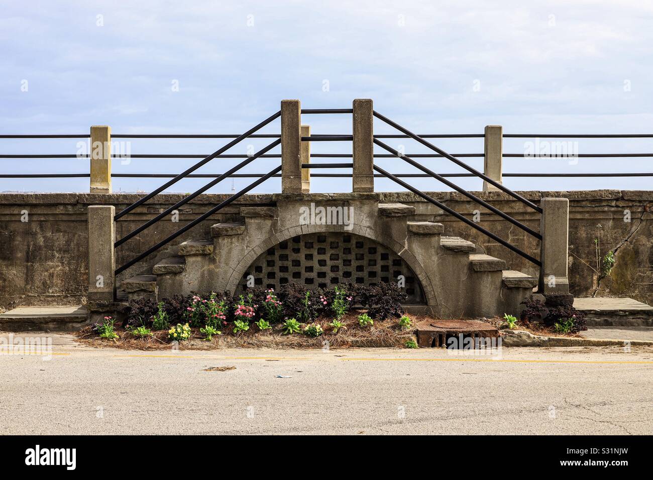
Below the bar that binds
Across the street along the battery itself, a few steps away from the previously identified intersection, are a set of concrete posts on top of a small set of stairs with three horizontal bars “binding” the two posts together. Directly below this is an area of soft soil periodically used for planting, and a grated concrete arch. The Japanese translation of the book infers that the bars are likely horizontal. Also, the masks in the painting show arched eyes and black eye slits that emulate the concrete arch and metal bars. Look at the large domed mask and how the eye is angled with a small platform on top, mimicking the contours of the staircase if appearing without the actual stairs on it. Considering the purpose of a mask to conceal something, the grated concrete vent is serving a similar purpose.

This location proves logistically viable in that the verse does not appear to give us precise coordinates for identifying the exact dig location in a manner we would expect if a random park location like Chicago was being applied. If the casque is found directly below the “bars” in a planter, our theoretical search grid is narrowed substantially.
While some might characterize this location as a “flower bed”, which is forbidden for physical investigation by the book, I have a few counter points. For starters, the Cleveland casque was located in a “planter” which could easily be considered a potential bed for flowers. Secondly, because the composition and density of the soil in the park makes digging difficult if not impossible in certain areas, an area of predictably soft soil is more likely for burial. Thirdly, the book says a casque could be buried as deep as 3 ½ feet, which really only makes sense if you are concerned with potential activity over it. Fourthly, based on Google map pictures, it seems that seasonal change overs and periods of vacancy are common for this plot of soil, so it is very possible there was nothing here when Byron buried the casque. Lastly, while some people insist that a casque must be buried within the borders of a park, the book makes it clear on the very first page that the casque may be hidden “…in your city or your local park…” making it a point to differentiate between the two and making this Charleston solution technically feasible.
Beside the long palm’s shadow
There are tall palm trees across the street from our proposed casque location that create a shadow. This line likely serves the double purpose of providing a context clue for South Carolina as the state flag includes the silhouette of a palm tree, while a palm shadow is arguably also included in image 2.
Embedded in the sand
Waits the Fair remuneration
White house close at hand
Directly beside our casque location to the north is a sandy patch of ground. This area is right along the confluence of the Ashley and Cooper Rivers which is why it is so sandy. A section of this material would need to be removed to apply viable planting soil, which makes our flower bed area “embedded in the sand”. Across the street with the palm trees is a white house. While these final devices manifest in a very superficial manner, they serve the purpose of narrowing and qualifying the precise casque location.
As mentioned previously, the item that seemingly represents Fort Sumter in image 1 is meant to physically represent White Point Gardens in this Charleston solution. This makes sense from a symbolic standpoint if you consider that a mask usually conceals something’s true identity. If superimposing the two images, the chin of the mask lines up with the southeastern corner of the park, and the sides of the mask match with Murray Blvd and E. Battery respectively. The reason we apply the chin to this area of the park is because it contains the Confederate Defenders of Charleston at Fort Sumter Monument, and the mask itself is designed to look like Fort Sumter.

When doing this, the other symbols from the mask line up with real locations. The single white star (stars also appear on the base of the statue) aligns with the location of the white house on Battery St. from the verse, and the house has the address number 1. The red, white, and blue strips line up with the location of an American flag on the other side of the park. The teeth inside of the mask’s mouth mimic the triangles all around the statue that appear side by side. When the mask is superimposed over the map of the park, and symbols on the mask are lined up with the corresponding locations, the shorthand on the mask points precisely to our proposed casque location. There is also a white dot on the mask to mark the casque location as well. Notice that the verse says “white house close at hand”, and the one white star, which we say represents the white house at 1 E Battery St., is very “close” to the short clock hand in the painting. These intertwined associations illuminate a profound condition of accurate geographic mirroring with multiple points of reference, effectively eliminating the possibility of a coincidental manifestation.

On either side of the mouth on the Fort Sumpter-esc device in image 2, appear asymmetrical triangles with white dots or points in each corner. In comparison, we just aligned three characteristics of the same device with the map, when connected, form a similar brand of triangle.
Lastly, lets talk about the gem appearing at the bottom right corner of the painting. The gem contains the number 75 in it. It is no giant leap to suppose that the number 75 might be a direct reference to the casque location. I had a reliable visiting friend count the holes in the vented concrete arch directly behind the proposed casque location. He counted 72. When you add the three bars above it, you get 75. As previously sited, the eyes on the masks in the painting combine black slits and arches, so it makes sense to combine the bars and the holes from the vented arch to arrive at the number 75. The casque is very likely to have been in the area directly below the horizontal bars based on this Charleston solution.

Sadly, the battery wall has been renovated numerous times over the years. A park’s representative has stated that this proposed location is commonly sited by investigators, while a casque has reportedly never been recovered there. Progress in one area has seemingly halted progress in another. If we had gotten to this sooner, retrieval would have been more than reasonable.
Other Evidence
-Charleston coordinates found in image
-Charleston Peninsula emulated on mask in image
-“Golden bug” on lion’s face connected to story by Edgar Allen Poe about Sullivan Island SC
-The silhouette of a palm tree on the woman’s body evokes imagery of the flag for South Carolina and connects to the verse’s mention of “long palm’s shadow”
Charleston Solution Pros:
-Logically applies JT clue regarding “romance”
-Incorporates all verse elements to the letter
-Generates a clear starting point and clear path to WPG through fully integrated verse and image instruction
-Linear progression that doesn’t inexplicably reverse course
-Explains use of the word “or” in corresponding verse lines
-More substantial application of image devices
-Logical dig location regarding soil density and composition
-Explains why precise dig location is seemingly unspecified
-Incorporates brand of symbolism and world play instrumental in resolved cases
Charleston Solution Cons:
-No direct link to Edward Blyden at WPG
-The dedication of the USS Maine Capstan is unlikely to appear in a catalog of dates, seemingly contradicting the JT
-Dig location not isolated from pedestrian traffic
-Not within park boundaries
-Does not incorporate Pearman Bridge as anything other than misdirection
Leave a Reply